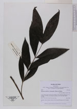
| Collector | Balslev, H. |
| Number | 8089 |
| Collected with | C. Grandez, D. Pedersen, B. Bergmann, G. del Aguila Panduro, Jim Chilo, A. Alvarado & J. Gonzales Baardales |
| Country | Peru |
| Subpart | Loreto |
| County | |
| Locality | Río Ucayali, 14.4 km W of Orellana, 185 km NW of Pucallpa. Km 17 on Orellana - El Dorado road. Disturbed primary forest. UTM 18M: 468395; 9237540 |
| Coordinates | 6° 53' 52.1'' S 75° 17' 9.9'' W |
| Minimum elevation (m) | 165 |
| Maximum elevation (m) | 0 |
| Start date | 2009/07/04 |
| End date | 0/00/00 |
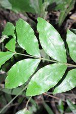
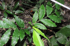
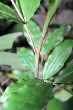
| Family | Arecaceae |
| Identification | Desmoncus mitis subsp. leptospadix (Mart.) A.J. Hend. |
| Determined by | H. Balslev |
| Identification qualifier | |
| Field notes | Juvenile. Liana. Cespitose. Stems to 50 cm long. HB transect no. 401, subunit 67 |
|