AAU Herbarium Database |
| New Search Modify Search |
| Collector | Balslev, H. |
| Number | 8057 |
| Collected with | C. Grandez, D. Pedersen, B. Bergmann, G. del Aguila Panduro, Jim Chilo, A. Alvarado & J. Gonzales Baardales |
| Country | Peru |
| Subpart | Loreto |
| County | |
| Locality | Río Ucayali, 5.6 km NW of Orellana, 182 km NW of Pucallpa. Disturbed primary forest. UTM 18M: 479468; 9240491 |
| Coordinates | 6° 52' 16.1'' S 75° 11' 9'' W |
| Minimum elevation (m) | 169 |
| Maximum elevation (m) | 0 |
| Start date | 2009/07/01 |
| End date | 0/00/00 |
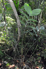
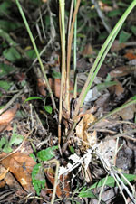
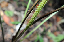
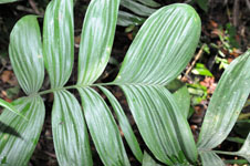
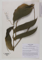
| Family | Arecaceae |
| Identification | Geonoma macrostachys var. acaulis (Mart.)A.J.Hend. |
| Determined by | Balslev H. |
| Identification qualifier | |
| Field notes | Solitary understory palm. Acaulescent. Leaves 10; leaf sheath 10 cm long, open; petiole 80 cm long, margined; rachis 31 cm long; lamina pinnate; pinnae 4-5 per side, irregularly inserted, in one single plane, basal pinna 22 cm long, middle pinna 22 cm long, apical pinna 22.5 cm long. Inflorescence interfoliar; prophyll 12 cm long, 1 cm wide, papery; peduncle 32 cm long, 0.5 cm thick, green; spike 10 cm long, 1 cm thick, green. HB transect 395, subunit 22. |
| |
| Display all 211 georeferenced records of Geonoma Geonoma macrostachys var. acaulis |
| New Search Modify Search |