AAU Herbarium Database |
| New Search Modify Search |
| Collector | Balslev, H. |
| Number | 8054 |
| Collected with | C. Grandez, D. Pedersen, B. Bergmann, G. del Aguila Panduro, Jim Chilo, A. Alvarado & J. Gonzales Baardales |
| Country | Peru |
| Subpart | Loreto |
| County | |
| Locality | Río Ucayali, 20 km NE of Orellana, 180 km NW of Pucallpa. W shore of oxbow lake, 4 km S of the village of Belaunde. Primary forest, periodically flooded. UTM 18M: 500163; 9245485 |
| Coordinates | 6° 49' 33.6'' S 74° 59' 54.7'' W |
| Minimum elevation (m) | 142 |
| Maximum elevation (m) | 0 |
| Start date | 2009/06/30 |
| End date | 0/00/00 |
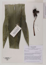
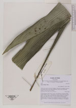
| Family | Arecaceae |
| Identification | Bactris bifida Mart. |
| Determined by | Balslev H. |
| Identification qualifier | |
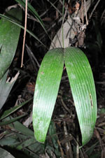
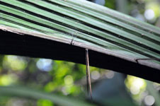
| Field notes | Colonial understory palm. Stem 1 m tall, 1 cm in diameter, covered by old leaf sheaths. Number of leaves 7; leaf sheath 20 cm long, closed; petiole 58 cm long; rachis 71 cm long, sheath, petiole and rachis with brown spines to 5 cm long; lamina entire, bifid, 104 cm long, 16 cm wide. Infructescence interfoliar; peduncular bract 16 cm long, brown; peduncle 20 cm long, 0.5 cm thick, green; rachis 4 cm long, 0.2 cm thick, green unbranched. HB transect no. 394, subunit 23 |

| |
| Display all 26 georeferenced records of Bactris Bactris bifida |
| New Search Modify Search |