AAU Herbarium Database |
| New Search Modify Search |
| Collector | Balslev, H. |
| Number | 8052 |
| Collected with | C. Grandez, D. Pedersen, B. Bergmann, G. del Aguila Panduro, Jim Chilo, A. Alvarado & J. Gonzales Baardales |
| Country | Peru |
| Subpart | Loreto |
| County | |
| Locality | Río Ucayali, 20 km NE of Orellana, 180 km NW of Pucallpa. W shore of oxbow lake, 4 km S of the village of Belaunde. Primary forest, periodically flooded. UTM 18M: 500218; 9245441 |
| Coordinates | 6° 49' 35.1'' S 74° 59' 52.9'' W |
| Minimum elevation (m) | 130 |
| Maximum elevation (m) | 0 |
| Start date | 2009/06/30 |
| End date | 0/00/00 |
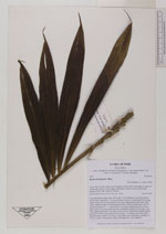
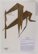
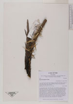
| Family | Arecaceae |
| Identification | Bactris brongniartii Mart. |
| Determined by | Balslev H. |
| Identification qualifier | |
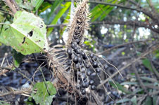
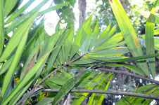
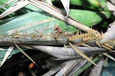
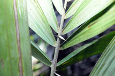
| Field notes | Colonial midstory palm. Stem 384 m tall, 3 cm in diameter, with black spines below nodes; internodes 7 cm long. Number of leaves 5; leaf sheath 30 cm long, closed; petiole 28 cm long; rachis 56 cm long, sheath, petiole and rachis with yellow, flattened spines; lamina pinnate, bushy; number of pinnae per side 20, inserted in groups of 1 - 5, basal pinna 19 cm long, middle pinna 28 cm long, apical pinna 18 cm long. Infructescence interfoliar; prophyll 20 cm long, 3 cm wide; peduncular bract 49 cm long, woody, brown, with yellow flattened spines, inserted 4 cm from base; peduncle 29 cm long, 1 cm thick, green with yellow flattened spines; rachis 7 cm long, 0.5 cm thick, green with spines; rachillae 17, 18-20 cm long. Fruits globose, black. HB transect no. 394, subunit 6 |

| |
| Display all 32 georeferenced records of Bactris Bactris brongniartii |
| New Search Modify Search |