AAU Herbarium Database |
| New Search Modify Search |
| Collector | Balslev, H. |
| Number | 8046 |
| Collected with | C. Grandez, D. Pedersen, B. Bergmann, G. del Aguila Panduro, Jim Chilo, A. Alvarado & J. Gonzales Baardales |
| Country | Peru |
| Subpart | Loreto |
| County | |
| Locality | Río Ucayali, 18 km E of Orellana, 170 km NW of Pucallpa. 2 hours by boat upriver from the village of Alfonzo Ugarte and 1 hour walking. Primary forest on tierra firme. UTM 18M: 500445; 9234683 |
| Coordinates | 6° 55' 25.4'' S 74° 59' 45.5'' W |
| Minimum elevation (m) | 156 |
| Maximum elevation (m) | 0 |
| Start date | 2009/06/29 |
| End date | 0/00/00 |
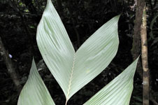
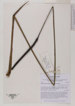
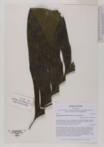
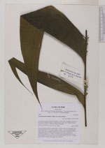
| Family | Arecaceae |
| Identification | Geonoma macrostachys var. macrostachys Mart. |
| Determined by | H. Balslev |
| Identification qualifier | |
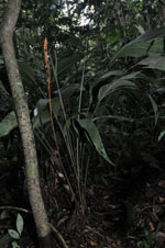
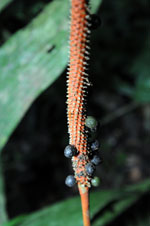
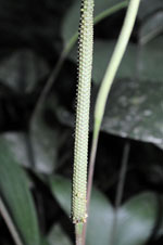
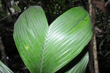
| Field notes | Solitary understory palm. Acaulescent, 1.5 m tall. Leaves 9; leaf sheath 12 cm long, open; petiole 53 cm long, margined; rachis 77 cm long; lamina pinnate; pinnae 3 per side, irregularly inserted, in one single plane, basal pinna 51 cm long, middle pinna 53 cm long, apical pinna 40 cm long. Inflorescence interfoliar; prophyll 12 cm long, 2 cm wide, papery; peduncular bract 35 cm long; peduncle 106 cm long, 0.3 cm wide, green; spike 20 cm long, 1 cm wide, green. Flowers sunken. HB transect 392, subunit 24. |
| |
| Display all 220 georeferenced records of Geonoma Geonoma macrostachys var. macrostachys |
| New Search Modify Search |