AAU Herbarium Database |
| New Search Modify Search |
| Collector | Balslev, H. |
| Number | 8039 |
| Collected with | C. Grandez, D. Pedersen, B. Bergmann, G. del Aguila Panduro, Jim Chilo, A. Alvarado & J. Gonzales Baardales |
| Country | Peru |
| Subpart | Loreto |
| County | |
| Locality | Río Ucayali, 16.5 km SE of Orellana, 161 km NW of Pucallpa. Top of ridge 2.5 km E of the Village of Monte de los Olivos. Primary forest. UTM 18M: 491574; 9221860 |
| Coordinates | 7° 2' 23'' S 75° 4' 34.7'' W |
| Minimum elevation (m) | 283 |
| Maximum elevation (m) | 0 |
| Start date | 2009/06/27 |
| End date | 0/00/00 |
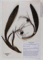
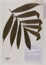
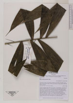
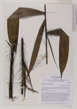
| Family | Arecaceae |
| Identification | Bactris macroacantha Mart. |
| Determined by | Balslev H. |
| Identification qualifier | |
| Field notes | Cespitose understory palm. Stem 150 cm long, 3 cm in diameter, covered by old leaf bases. Number of leaves 15; leaf sheath 15 cm long, closed; petiole 78 cm long; rachis 127 cm long, sheath, petiole and rachis with black spines; lamina pinnate, bushy; pinnae per side 15, inserted in groups of 1-2, basal pinna 26 cm long, middle pinna 28 cm long, apical pinna 17 cm long. Inflorescence interfoliar; prophyll 19 cm long, 2.5 cm wide; peduncular bract 40 cm long, inserted 7 cm from base, woody, brown, with brown spines; peduncle 25 cm long, with brown spines; rachis 5 cm long, 0.3 cm wide, green; rachillae 7, 5-10 cm long. Fruits globose, green. HB transect 391, outside subunit 49. |
| |
| Display all 27 georeferenced records of Bactris Bactris macroacantha |
| New Search Modify Search |