| Collector | Balslev, H. |
| Number | 8030 |
| Collected with | C. Grandez, D. Pedersen, B. Bergmann, G. del Aguila Panduro, Jim Chilo, A. Alvarado & J. Gonzales Baardales |
| Country | Peru |
| Subpart | Loreto |
| County | |
| Locality | Río Ucayali, 16 km SE of Orellana, 161 km NW of Pucallpa. 2 km E of the Village of Monte de los Olivos. Transect starts at the foot of the hills and goes up. Undisturbed primary forest on hills. Sandy soil. UTM 18M: 491659; 9222108 |
| Coordinates | 7° 2' 14.9'' S 75° 4' 31.9'' W |
| Minimum elevation (m) | 268 |
| Maximum elevation (m) | 0 |
| Start date | 2009/06/26 |
| End date | 0/00/00 |
| Family | Arecaceae |
| Identification | Bactris acanthocarpa Mart. |
| Determined by | Balslev H. |
| Identification qualifier | |
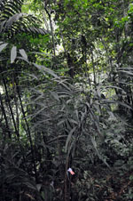
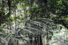
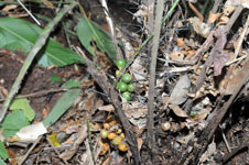
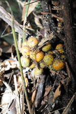
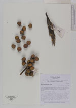
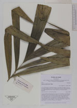
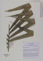
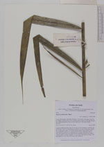
| Field notes | Cespitose understory palm. Stem 30 cm long, 10 cm in diameter, covered by old leaf sheaths. Leaves 10; leaf sheath more than 23 cm long, closed, spiny; petiole 87 cm long, spiny; rachis 135 cm long; lamina pinnate, bushy; pinnae 19 per side, inserted in groups of 1-4, basal pinna 46 cm long, middle pinna 46 cm long, apical pinna 28 cm long. Infructescence interfoliar; peduncle more than 4 cm long; rachis 5 cm long; rachillae 7, to 3 cm long. Fruits green to orange, with black spines to 0.2 cm long. HB transect 389, subunit 82. |
|
 Other records of Bactris acanthocarpa