AAU Herbarium Database |
| New Search Modify Search |
| Collector | Balslev, H. |
| Number | 8024 |
| Collected with | C. Grandez, D. Pedersen, B. Bergmann, G. del Aguila Panduro, Jim Chilo, A. Alvarado & J. Gonzales Baardales |
| Country | Peru |
| Subpart | Loreto |
| County | |
| Locality | Río Ucayali, 16 km SE of Orellana, 161 km NW of Pucallpa. 2 km E of the Village of Monte de los Olivos. Transect starts at the foot of the hills and goes up. Undisturbed primary forest on hills. Sandy soil. UTM 18M: 491444; 9222077 |
| Coordinates | 7° 2' 15.9'' S 75° 4' 38.9'' W |
| Minimum elevation (m) | 310 |
| Maximum elevation (m) | 0 |
| Start date | 2009/06/26 |
| End date | 0/00/00 |
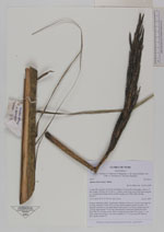
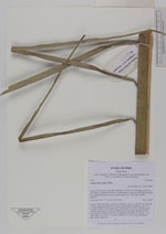
| Family | Arecaceae |
| Identification | Attalea microcarpa Mart. |
| Determined by | Balslev H. |
| Identification qualifier | |
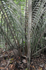
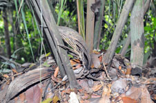
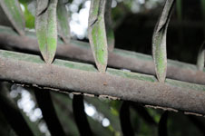
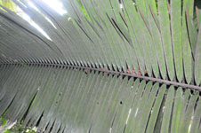
| Field notes | Solitary understory palm. Acaulescent. Number of leaves 9; petiole more than 60 cm long, margined; rachis 502 cm long; lamina pinnate; pinnae per side 114, regularly inserted, in one single plane, basal pinna 22 cm long, middle pinna 85 cm long, apical pinna 16 cm long. Inflorescence interfoliar; peduncular bract more than 60 cm long, woody, brown; peduncle more than 24 cm long, 1.1 cm wide; rachis 24 cm long, 1 cm wide; rachillae 27, 7-10 cm long. HB transect 389, outside subunit 37. |
| |
 Other records of Attalea microcarpa Other records of Attalea microcarpaThe map displays only records from the Aarhus Herbarium Database. The records may not represent the full distribution of Attalea microcarpa |
| New Search Modify Search |