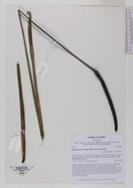
| Collector | Balslev, H. |
| Number | 8019 |
| Collected with | C. Grandez, D. Pedersen, B. Bergmann, G. del Aguila Panduro, Jim Chilo, A. Alvarado & J. Gonzales Baardales |
| Country | Peru |
| Subpart | Loreto |
| County | |
| Locality | Río Ucayali, 14 km SE of Orellana, 163 km NW of Pucallpa, 1.5 km E of the Village of Monte de los Olivos. Primary forest on very steep slopes. UTM 18M: 490498; 9223038 |
| Coordinates | 7° 1' 44.6'' S 75° 5' 9.7'' W |
| Minimum elevation (m) | 213 |
| Maximum elevation (m) | 0 |
| Start date | 2009/06/25 |
| End date | 0/00/00 |
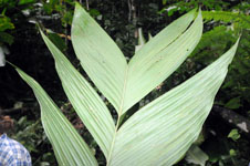
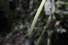
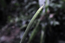
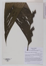
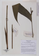
| Family | Arecaceae |
| Identification | Geonoma macrostachys var. macrostachys Mart. |
| Determined by | H. Balslev |
| Identification qualifier | |
| Field notes | Solitary understory palm. Acaulescent. Leaves 6; leaf sheath 19 cm long, open; petiole 76 cm long, margined; rachis 69 cm long; lamina pinnate; pinnae irregulary inserted, in one single plane, basal pinna 26 cm long, middle pinna 45 cm long, apical pinna 43 cm long. Inflorescence interfoliar; prophyll 14 cm long, 0.6 cm wide; peduncular bract 30 cm long, inserted 0.6 cm from base; peduncle 80 cm long, 0.5 cm wide, green; spike 20 cm long, 1 cm wide, green. HB transect 388, subunit 56. |
|