| Collector | Balslev, H. |
| Number | 8018 |
| Collected with | C. Grandez, D. Pedersen, B. Bergmann, G. del Aguila Panduro, Jim Chilo, A. Alvarado & J. Gonzales Baardales |
| Country | Peru |
| Subpart | Loreto |
| County | |
| Locality | Río Ucayali, 14 km SE of Orellana, 163 km NW of Pucallpa, 1.5 km E of the Village of Monte de los Olivos. Primary forest on very steep slopes. UTM 18M: 490371; 9223068 |
| Coordinates | 7° 1' 43.6'' S 75° 5' 13.9'' W |
| Minimum elevation (m) | 204 |
| Maximum elevation (m) | 0 |
| Start date | 2009/06/25 |
| End date | 0/00/00 |
| Family | Arecaceae |
| Identification | Desmoncus mitis subsp. leptospadix (Mart.) A.J. Hend. |
| Determined by | Balslev H. |
| Identification qualifier | |
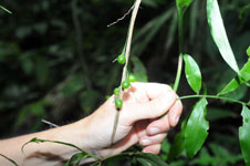
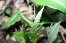
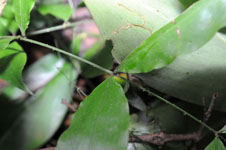
| Field notes | Liana. Stem 150 cm long, 0.3 cm in diameter, green. Number of leaves 10; leaf sheath 18 cm long, closed; lamina pinnate; pinnae more or less regularly inserted, in one single plane, basal pinna 12 cm long, middle pinna 13 cm long, apical pinna 14 cm long. Inflorescence interfoliar; peduncular bract 22 cm long; peduncle 6 cm long; rachis 12 cm long; rachillae 3, to 2 cm long. Fruits green, elipsoid. HB transect no. 388, subunit 27. |

|