AAU Herbarium Database |
| New Search Modify Search |
| Collector | Balslev, H. |
| Number | 8006 |
| Collected with | C. Grandez, D. Pedersen, B. Bergmann, G. del Aguila Panduro, Jim Chilo, A. Alvarado & J. Gonzales Baardales |
| Country | Peru |
| Subpart | Loreto |
| County | |
| Locality | Río Ucayali, 15 km SE of Orellana, 162 km NW of Pucallpa. 1 km E of the Village of Monte de los Olivos. Primary forest. UTM 18M: 489710; 9222456 |
| Coordinates | 7° 2' 3.6'' S 75° 5' 35.4'' W |
| Minimum elevation (m) | 160 |
| Maximum elevation (m) | 0 |
| Start date | 2009/06/25 |
| End date | 0/00/00 |
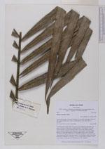
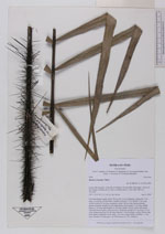
| Family | Arecaceae |
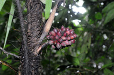
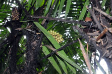
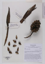
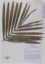
| Identification | Bactris concinna Mart. |
| Determined by | Balslev H. |
| Identification qualifier | |
| Field notes | Colonial midstory palm. Stem 150 cm tall, 3 cm in diameter; internodes 7 cm long, covered by old leaf bases. Number of leaves 7; leaf sheath 35 cm long, closed; petiole 62 cm long, margined; rachis 144 cm long; lamina pinnate, pinnae regularly inserted, in one single plane, basal pinna 37 cm long, middle pinna 42 cm long, apical pinna 20 cm long; sheath, petiole, rachis and pinnae with dark brown spines. Infructescence interfoliar; prophyll 17 cm long, 1.3 cm wide; peduncular bract 30 cm long, inserted 7 cm from base, woody, brown with black spines; peduncle 24 cm long, 1 cm wide; rachis absent; rachillae 1, 7 cm long. Number of fruits aprox. 60. HB transect no. 387, subunit 1 |
| |
| Display all 48 georeferenced records of Bactris Bactris concinna |
| New Search Modify Search |