| Collector | Balslev, H. |
| Number | 8001 |
| Collected with | C. Grandez, D. Pedersen, B. Bergmann, G. del Aguila Panduro, Jim Chilo, A. Alvarado & J. Gonzales Baardales |
| Country | Peru |
| Subpart | Loreto |
| County | |
| Locality | Río Ucayali, 11 km S of Orellana, 168 km NW of Pucallpa. Village of Jost O’lea, La finca de Sr. José Antonio Mendoza. Tall primary forest on rather flat ground. UTM 18M: 480977; 9224665 |
| Coordinates | 7° 0' 51.5'' S 75° 10' 20'' W |
| Minimum elevation (m) | 140 |
| Maximum elevation (m) | 0 |
| Start date | 2009/06/23 |
| End date | 0/00/00 |
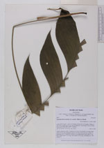
| Family | Arecaceae |
| Identification | Geonoma macrostachys var. acaulis (Mart.)A.J.Hend. |
| Determined by | Balslev H. |
| Identification qualifier | |
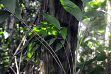
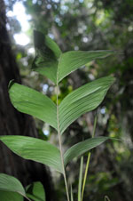
| Field notes | Solitary understory palm. Acaulescent. Leaves 6; leaf sheath 5 cm long, open; petiole 52 cm long, margined; rachis 29 cm long; lamina pinnate; number of pinnae per side 3, irregularly inserted, in one single plane, basal pinna 15 cm long, middle pinna 17 cm long, apical pinna 19 cm long. HB transect no. 384, subunit 71 |
|