| Collector | Balslev, H. |
| Number | 7987 |
| Collected with | C. Grandez, D. Pedersen, B. Bergmann, G. del Aguila Panduro, Jim Chilo, A. Alvarado & J. Gonzales Baardales |
| Country | Peru |
| Subpart | Loreto |
| County | |
| Locality | Río Ucayali, 17 km NE of Contamana, 139 km N of Pucallpa. End of Contamana - Aguas Calientes road. Tall primary forest on steep slopes. UTM 18M: 505591; 9203269 |
| Coordinates | 7° 12' 28.4'' S 74° 56' 57.7'' W |
| Minimum elevation (m) | 227 |
| Maximum elevation (m) | 0 |
| Start date | 2009/06/20 |
| End date | 0/00/00 |
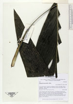
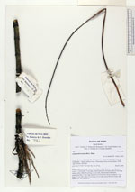
| Family | Arecaceae |
| Identification | Chamaedorea pauciflora Mart. |
| Determined by | Balslev H. |
| Identification qualifier | |
| Field notes | Solitary understory palm. Stem 64 cm long, 1 cm in diameter, smooth, green. Leaves 7; leaf sheath 12 cm long, closed; petiole 20 cm long; rachis 33 cm long; lamina entire, bifid, 68 cm long, 22 cm wide. Inflorescence interfoliar; peduncular bract 13 cm long, inserted 5 cm from base, brown; peduncle 17 cm long, 0.3 cm wide; spike 22 cm long, 0.5 cm wide, green; flowers in bud. HB transect no. 382, subunit 62 |
|