| Collector | Balslev, H. |
| Number | 7975 |
| Collected with | C. Grandez, D. Pedersen, B. Bergmann, G. del Aguila Panduro, Jim Chilo, A. Alvarado & J. Gonzales Baardales |
| Country | Peru |
| Subpart | Loreto |
| County | |
| Locality | Río Ucayali, 10 km NE of Contamana, 135 km N of Pucallpa. Km 13 on Contamana - Aguas Calientes road, left side of road. Primary forest. UTM 18M: 500818; 917427 |
| Coordinates | 7° 15' 38.7'' S 74° 59' 33.3'' W |
| Minimum elevation (m) | 165 |
| Maximum elevation (m) | 0 |
| Start date | 2009/06/19 |
| End date | 0/00/00 |
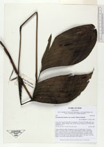
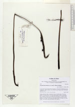
| Family | Arecaceae |
| Identification | Geonoma macrostachys var. acaulis (Mart.)A.J.Hend. |
| Determined by | Balslev H. |
| Identification qualifier | |
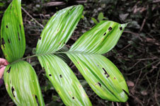
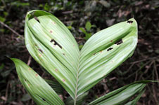
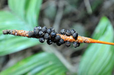
| Field notes | Solitary understory palm. Acaulescent. Leaves 6; sheath open, 17 cm long; petiole 37 cm long; rachis 33 cm long; lamina pinnate; number of pinnae per side 3, regularly inserted, in one single plane, basal pinna 23 cm long, middle pinna 19 cm long, apical pinna 18 cm long. Infructescence interfoliar, spicate; peduncle 43 cm long, 0.4 cm wide, green-orange; spike 11 cm long, 1 cm wide, orange. Fruits globose, black. HB transect 380, subunit 17. |
|