| Collector | Balslev, H. |
| Number | 7972 |
| Collected with | C. Grandez, D. Pedersen, B. Bergmann, G. del Aguila Panduro, Jim Chilo, A. Alvarado & J. Gonzales Baardales |
| Country | Peru |
| Subpart | Loreto |
| County | |
| Locality | Río Ucayali, 6 km N of Contamana, 132 km NW of Pucallpa. Km 8 on Contamana - Aguas Calientes road, left side of road. Primary forest on slopes. UTM 18M: 498915; 9193356 |
| Coordinates | 7° 17' 51.2'' S 75° 0' 35.4'' W |
| Minimum elevation (m) | 0 |
| Maximum elevation (m) | 0 |
| Start date | 2009/06/18 |
| End date | 0/00/00 |
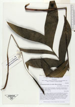
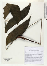
| Family | Arecaceae |
| Identification | Geonoma macrostachys var. acaulis (Mart.)A.J.Hend. |
| Determined by | Balslev H. |
| Identification qualifier | |
| Field notes | Solitary understory palm. Acaulescent. Leaves 5; leaf sheath open, 10 cm long; rachis 62 cm long; lamina pinnate; number of pinnae per side 3, irregularly inserted, in one single plane, basal pinna 25 cm long, middle pinna 25 cm long, apical pinna 24 cm long. Inflorescence interfoliar, spicate; prophyll 7 cm long, papery, inserted 0.8 cm above the base; peduncular bract 14 cm long, brown; peduncle 42 cm long, 0.4 cm wide; spike 9.5 cm long, 0.8 cm wide, green. Flowers green. HB transect 379, subunit 69 |
|