AAU Herbarium Database |
| New Search Modify Search |
| Collector | Balslev, H. |
| Number | 7939 |
| Collected with | C. Grandez, D. Pedersen, B. Bergmann, G. del Aguila Panduro, Jim Chilo, A. Alvarado & J. Gonzales Baardales |
| Country | Peru |
| Subpart | Loreto |
| County | |
| Locality | Río Ucayali, 57 km SW of Contamana, 102 km NW of Pucallpa. S side of Río Pisqui. Disturbed primary forest (many tractor tracks). UTM 18M: 473019; 9137390 |
| Coordinates | 7° 48' 13.5'' S 75° 14' 41'' W |
| Minimum elevation (m) | 160 |
| Maximum elevation (m) | 0 |
| Start date | 2009/06/12 |
| End date | 0/00/00 |
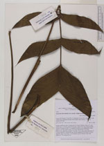
| Family | Arecaceae |
| Identification | Geonoma macrostachys var. acaulis (Mart.)A.J.Hend. |
| Determined by | Balslev H. |
| Identification qualifier | |
| Field notes | Solitary understory palm. Acaulescent, 80 cm tall. Number of leaves 10; leaf sheath open, 7 cm long; petiole 54 cm long; rachis 34 cm long; lamina pinnate; number of pinnae per side 4-5, irregularly inserted, in one single plane, basal pinna 22 cm long, middle pinna 19 cm long, apical pinna 15 cm long. Inflorescence interfoliar; prophyll 7 cm long, 1.5 cm wide; peduncular bract 19 cm long, inserted 6 cm from the base, brown; peduncle 64 cm long, 0.6 cm in diameter; spike 10 cm long, 1 cm in diameter, green. Flowers in bud. HB transect no. 370, subunit no. 64 |


| |
| Display all 211 georeferenced records of Geonoma Geonoma macrostachys var. acaulis |
| New Search Modify Search |