| Collector | Balslev, H. |
| Number | 7929 |
| Collected with | C. Grandez, D. Pedersen, B. Bergmann, G. del Aguila Panduro, Jim Chilo, A. Alvarado & J. Gonzales Baardales |
| Country | Peru |
| Subpart | Loreto |
| County | |
| Locality | Río Ucayali, 60 km SW of Contamana, 106 km NW of Pucallpa, Nueva Bellaunde. S side of Río Pisqui. Flat, rarely inundated ground. Disturbed forest with many tractor tracks. UTM 18M: 466896; 9136654 |
| Coordinates | 7° 48' 37.3'' S 75° 18' .9'' W |
| Minimum elevation (m) | 163 |
| Maximum elevation (m) | 0 |
| Start date | 2009/06/11 |
| End date | 0/00/00 |
| Family | Arecaceae |
| Identification | Astrocaryum faranae F.Kahn & E.Ferreira |
| Determined by | Balslev H. |
| Identification qualifier | |
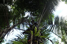
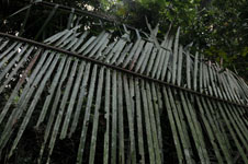
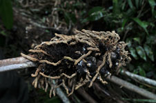
| Field notes | Solitary, canopy palm. Stem 6 m tall, 23 cm in diameter, covered by old leaf sheaths. Number of leaves 10; leaf sheath open, 150 cm long; petiole 23 cm long; rachis 6.37 m long; lamina pinnate; number of pinnae per side 101, regularly inserted, in one single plane, basal pinna 45 cm long, middle pinna 98 cm long, apical pinna 30 cm long, sheath and petiole covered with black spines. Inflorescence interfoliar; peduncle 110 cm long, 5 cm wide, rachis 26 cm long, 8 cm wide; rachillae 150, 10-15 cm long. HB transect no. 369, subunit no. 36 |
|
 Other records of Astrocaryum faranae