| Collector | Balslev, H. |
| Number | 7925 |
| Collected with | C. Grandez, D. Pedersen, B. Bergmann, G. del Aguila Panduro, Jim Chilo, A. Alvarado & J. Gonzales Baardales |
| Country | Peru |
| Subpart | Loreto |
| County | |
| Locality | Río Ucayali, 60 km SW of Contamana, 106 km NW of Pucallpa, Nueva Bellaunde. S side of Río Pisqui. Flat, rarely inundated ground. Disturbed forest with many tractor tracks. UTM 18M: 466822; 9136717 |
| Coordinates | 7° 48' 35.3'' S 75° 18' 3.4'' W |
| Minimum elevation (m) | 165 |
| Maximum elevation (m) | 0 |
| Start date | 2009/06/11 |
| End date | 0/00/00 |
| Family | Arecaceae |
| Identification | Geonoma macrostachys var. acaulis (Mart.)A.J.Hend. |
| Determined by | Balslev H. |
| Identification qualifier | |
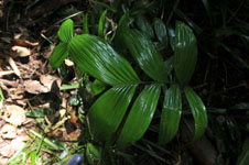
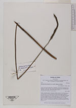
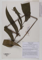
| Field notes | Solitary, understory palm. Acaulescent. Number of leaves 7; leaf sheath open, 7 cm long; petiole 68 cm long; rachis 28 cm long; lamina pinnate; number of pinnae per side 3, more or less regulary inserted, in one single plane, basal pinna 23 cm long, middle pinna 24 cm long, apical pinna 20 cm long. Inflorescence interfoliar; prophyll 7 cm long, 0.8 cm wide; peduncular bract 9 cm long, inserted 14 cm from the base, brown; peduncle 64 cm long, 0.3 cm in diameter; spike 13 cm long, 1 cm in diameter, green. Flowers sessile. HB transect no. 369, subunit no. 16 |
|