AAU Herbarium Database |
| New Search Modify Search |
| Collector | Balslev, H. |
| Number | 7919 |
| Collected with | C. Grandez, D. Pedersen, B. Bergmann, G. del Aguila Panduro, Jim Chilo, A. Alvarado & J. Gonzales Baardales |
| Country | Peru |
| Subpart | Loreto |
| County | |
| Locality | Río Ucayali, 31 km SE of Contamana, 95 km NW of Pucallpa. 6 km up Quebrada Cashiboya. Disturbed primary forest. UTM 18M: 510651; 9158617 |
| Coordinates | 7° 36' 42.5'' S 74° 54' 12.4'' W |
| Minimum elevation (m) | 144 |
| Maximum elevation (m) | 0 |
| Start date | 2009/06/09 |
| End date | 0/00/00 |
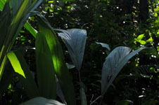
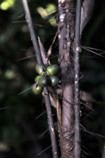
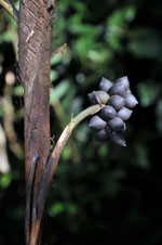
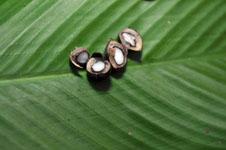
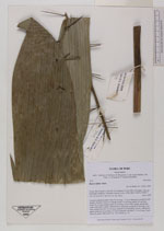
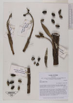
| Family | Arecaceae |
| Identification | Bactris bifida Mart. |
| Determined by | Balslev H. |
| Identification qualifier | |
| Field notes | Colonial understory palm. Stem 56 cm long, 1.5 cm in diameter, covered by leaf sheaths. Number of leaves 9; sheath closed, 19 cm long; petiole 38 cm long; rachis 48 cm long; lamina entire, 80 cm long, 29 cm wide; sheath, petiole and rachis with yellow spines. Infructescence interfoliar; prophyll 10 cm long, 1 cm wide; peduncular bract 18 cm long, inserted 5 cm from base, brown, with brown spines; peduncle 16 cm long, 0.5 cm in diameter; rachillae 2, 2.4 cm long. Fruits ellipsoid, purple. HB transect no. 368, subunit no. 29 |
| |
| Display all 26 georeferenced records of Bactris Bactris bifida |
| New Search Modify Search |