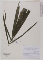
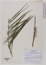
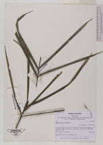
| Collector | Balslev, H. |
| Number | 7911 |
| Collected with | C. Grandez, D. Pedersen, B. Bergmann, G. del Aguila Panduro, Jim Chilo, A. Alvarado & J. Gonzales Baardales |
| Country | Peru |
| Subpart | Loreto |
| County | |
| Locality | Río Ucayali, 17 km SW of Contamana, 115 km NW of Pucallpa. App. 25 km from the village of Santa Rosa, N side of river. Primary forest. UTM 18M: 492221; 9171751 |
| Coordinates | 7° 29' 34.8'' S 75° 4' 13.8'' W |
| Minimum elevation (m) | 0 |
| Maximum elevation (m) | 0 |
| Start date | 2009/06/08 |
| End date | 0/00/00 |
| Family | Arecaceae |
| Identification | Syagrus sancona Karsten |
| Determined by | Balslev H. |
| Identification qualifier | |
| Field notes | Juvenile. HB transect no. 366, subunit no. 97 |
|
 Other records of Syagrus sancona