| Collector | Balslev, H. |
| Number | 7906 |
| Collected with | C. Grandez, D. Pedersen, B. Bergmann, G. del Aguila Panduro, Jim Chilo, A. Alvarado & J. Gonzales Baardales |
| Country | Peru |
| Subpart | Loreto |
| County | |
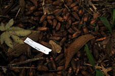
| Locality | Río Ucayali, 20 km SW of Contamana, 120 km NW of Pucallpa. S side of the river, 500 m inland. Primary forest, disturbed by logging, dominated by Attalea phalerata. UTM 18M: 487885; 9171144 |
| Coordinates | 7° 29' 54.5'' S 75° 6' 35.3'' W |
| Minimum elevation (m) | 147 |
| Maximum elevation (m) | 0 |
| Start date | 2009/06/07 |
| End date | 0/00/00 |
| Family | Arecaceae |
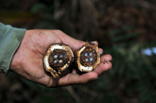
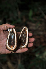
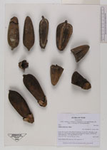
| Identification | Attalea phalerata Mart. |
| Determined by | Balslev H. |
| Identification qualifier | |
| Field notes | Fruits collected. HB transect no. 364, subunit no. 71 |
|
 Other records of Attalea phalerata