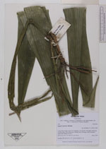
| Collector | Balslev, H. |
| Number | 7901 |
| Collected with | C. Grandez, D. Pedersen, B. Bergmann, G. del Aguila Panduro, Jim Chilo, A. Alvarado & J. Gonzales Baardales |
| Country | Peru |
| Subpart | Loreto |
| County | |
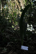
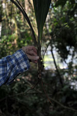
| Locality | Río Ucayali, 5 km S of Contamana, 122 km NW of Pucallpa. North side of oxbow lake, 100 m from shore. Primary forest. Restinga, rarely inundated. UTM 18M: 499408; 9183111 |
| Coordinates | 7° 23' 24.9'' S 75° 0' 19.3'' W |
| Minimum elevation (m) | 141 |
| Maximum elevation (m) | 0 |
| Start date | 2009/06/06 |
| End date | 0/00/00 |
| Family | Arecaceae |
| Identification | Syagrus sancona Karsten |
| Determined by | Balslev H. |
| Identification qualifier | |
| Field notes | Seedling. HB transect no. 363, outside subunit no. 24 |
|
 Other records of Syagrus sancona