AAU Herbarium Database |
| New Search Modify Search |
| Collector | Balslev, H. |
| Number | 7897 |
| Collected with | C. Grandez, D. Pedersen, B. Bergmann, G. del Aguila Panduro, Jim Chilo, A. Alvarado & J. Gonzales Baardales |
| Country | Peru |
| Subpart | Loreto |
| County | |
| Locality | Río Ucayali, 8 km SE of Contamana, 121 km NW of Pucallpa, ca. 2 km NE of the river. Primary forest on hilly slopes. UTM 18M: 505660; 9184575 |
| Coordinates | 7° 22' 37.2'' S 74° 56' 55.4'' W |
| Minimum elevation (m) | 194 |
| Maximum elevation (m) | 194 |
| Start date | 2009/06/05 |
| End date | 0/00/00 |
| Family | Arecaceae |
| Identification | Astrocaryum faranae F.Kahn & E.Ferreira |
| Determined by | Balslev H. |
| Identification qualifier | |
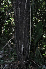
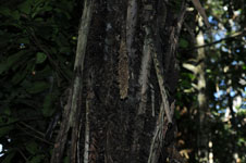
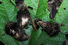
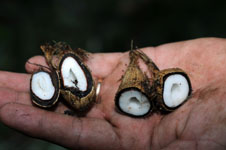
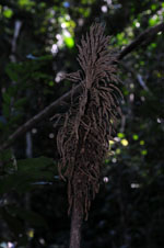
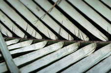
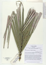
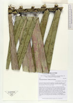
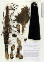
| Field notes | Solitary palm. Stem 4 m tall, 20 cm in diameter, covered by old leaf sheaths. Number of leaves 10; leaf sheath open, 130 cm long; petiole 2 cm long, section margined; rachis 7 m long; sheath, petiole and rachis with black spines; lamina pinnate; number of pinnae per side 100, regularly inserted, in one single plane, abaxial side white, middle pinna 105 cm long, apical pinna 40 cm long. Infructescence interfoliar; prophyll 87 cm long, 10 cm wide, spiny; peduncular bract 75 cm long, inserted 120 cm from the base, black, woody, spiny; peduncle 145 cm long, 3-5 cm in diameter; rachis 25 cm long, 3.5 cm in diameter; rachillae 150, 10-14 cm long. Fruits spiny. HB transect no. 362, outside subunit no. 55 |
| |
 Other records of Astrocaryum faranae Other records of Astrocaryum faranaeThe map displays only records from the Aarhus Herbarium Database. The records may not represent the full distribution of Astrocaryum faranae |
| New Search Modify Search |