AAU Herbarium Database |
| New Search Modify Search |
| Collector | Balslev, H. |
| Number | 7892 |
| Collected with | C. Grandez, D. Pedersen, B. Bergmann, G. del Aguila Panduro, Jim Chilo, A. Alvarado & J. Gonzales Baardales |
| Country | Peru |
| Subpart | Loreto |
| County | |
| Locality | Río Ucayali, 8 km SE of Contamana, 121 km NW of Pucallpa, ca. 2 km NE of the river. Primary forest on hilly slopes. UTM 18M: 505559; 9184534 |
| Coordinates | 7° 22' 38.5'' S 74° 56' 58.7'' W |
| Minimum elevation (m) | 191 |
| Maximum elevation (m) | 191 |
| Start date | 2009/06/05 |
| End date | 0/00/00 |
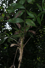
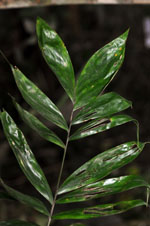
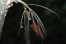
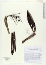
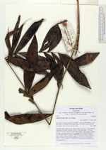
| Family | Arecaceae |
| Identification | Bactris maraja var. maraja Mart. |
| Determined by | Balslev H. |
| Identification qualifier | |
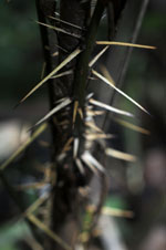
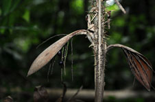
| Field notes | Understory palm, cespitose with 4 stems. Stems to 2 m long, 1.5 cm in diameter; internodes 3.5 cm long. Number of leaves 7; leaf sheath open, 15 cm long; petiole 26 cm long; rachis 48 cm long; lamina pinnate, bushy; number of pinnae per side 9, inserted in groups of 2-3, basal pinna 24 cm long, middle pinna 17 cm long, apical pinna 15 cm long; sheath and petiole with yellow, flattened spines. Infructescence interfoliar; prophyll 10 cm long, 1 cm thick; peduncular bract 13 cm long, brown, woody; peduncle 12 cm long, 0.3 cm in diameter; rachis 2 cm long; rachillae 5, 5 cm long. Fruits black, globose. HB transect no. 362, subunit no. 34 |

| |
| Display all 55 georeferenced records of Bactris Bactris maraja var. maraja |
| New Search Modify Search |