| Collector | Balslev, H. |
| Number | 7882 |
| Collected with | C. Grandez, D. Pedersen, B. Bergmann, G. del Aguila Panduro, Jim Chilo, A. Alvarado & J. Gonzales Baardales |
| Country | Peru |
| Subpart | Loreto |
| County | |
| Locality | Río Ucayali, 7 km SE of Contamana, 121 km NW of Pucallpa, ca. 2.5 km NE of the river. Primary forest on steep hills. UTM 18M: 504861; 9184791 |
| Coordinates | 7° 22' 30.2'' S 74° 57' 21.4'' W |
| Minimum elevation (m) | 128 |
| Maximum elevation (m) | 203 |
| Start date | 2009/06/04 |
| End date | 0/00/00 |
| Family | Arecaceae |
| Identification | Attalea phalerata Mart. |
| Determined by | Balslev H. |
| Identification qualifier | |
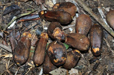
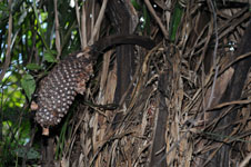
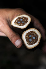
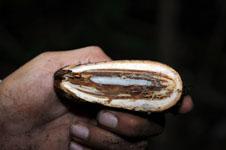
| Field notes | Solitary canopy palm. Stem about 3 m tall, 65 cm in diameter, covered by old leaf sheaths. Only fruits collected. HB transect no. 361, subunit no. 67 |
|
 Other records of Attalea phalerata