| Collector | Balslev, H. |
| Number | 7864 |
| Collected with | C. Grandez, G. Criollo, D. Pedersen, L. Stewart, I. Nicolajsen, W. Eiserhardt, D. Lindvig |
| Country | Peru |
| Subpart | Ucayali-Atalaya |
| County | |
| Locality | Rio Ucayali, 1km W of Iparia, 104km S of Pucallpa (UTM 8968373 S; 561771 W). Rainforest on terrace, not inundated acc to local informants, with old tractor trails. |
| Coordinates | 9° 19' 55.9'' S 74° 26' 15'' W |
| Minimum elevation (m) | 173 |
| Maximum elevation (m) | 0 |
| Start date | 2008/10/23 |
| End date | 0/00/00 |
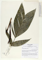
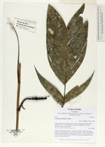
| Family | Arecaceae |
| Identification | Geonoma arundinacea Mart. |
| Determined by | H. Balslev |
| Identification qualifier | |
| Field notes | Cespitose understory palm. Stem 1.5m long, 0.4cm thick. Sheath 7cm, open; petiole 13cm, margined, green; rachis 25cm; lamina 33 x 19cm, entire and bifid or sligthly divided. Inflorescence interfoliar; prophyll 2.5cm long; peduncle 6cm long, 0.4cm thick, smooth; rachis 10cm long, 0.5cm thick, unbranched; flowers sunken. Transect HB358-SU65. |
_HB7864_Geonoma_arundinacea.jpg)
_HB7864_Geonoma_arundinacea.jpg)
|