AAU Herbarium Database |
| New Search Modify Search |
| Collector | Balslev, H. |
| Number | 7855 |
| Collected with | C. Grandez, G. Criollo, D. Pedersen, L. Stewart, I. Nicolajsen, W. Eiserhardt, D. Lindvig |
| Country | Peru |
| Subpart | Ucayali-Atalaya |
| County | |
| Locality | Rio Ucayali, W bank 121km S of Pucallpa (UTM 8954939 S; 582940 W). Flood plain forest with very open understory between levees, patches with very dense liana tangles. |
| Coordinates | 9° 27' 12'' S 74° 14' 40.1'' W |
| Minimum elevation (m) | 173 |
| Maximum elevation (m) | 0 |
| Start date | 2008/10/22 |
| End date | 0/00/00 |
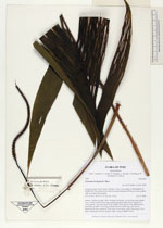
| Family | Arecaceae |
| Identification | Geonoma brongniartii Mart. |
| Determined by | H. Balslev |
| Identification qualifier | |
| Field notes | Solitary, understory palm. Stem creeping, ascending. Leaves 8 per stem; sheath 16cm, closed; petiole 28cm long, margined, green; rachis 38cm; lamina 53 x 27cm; pinnae 3 per side, basal 21cm, middle 23cm, apical 21cm. Inflorescence interfoliar; prophyll 12cm long; peduncular bract 18cm long, soft, brown, inserted at the base; peduncle 35cm long, 0.3cm thick; rachis 18cm long, 0.5cm thick, unbranched; flowers sunken, white. Transect HB357-SU11. |
_HB7855_Geonoma_brongniartii.jpg)
_HB7855_Geonoma_brongniartii.jpg)
_HB7855_Geonoma_brongniartii.jpg)
| |
| Display all 110 georeferenced records of Geonoma Geonoma brongniartii |
| New Search Modify Search |