AAU Herbarium Database |
| New Search Modify Search |
| Collector | Balslev, H. |
| Number | 7852 |
| Collected with | C. Grandez, G. Criollo, D. Pedersen, L. Stewart, I. Nicolajsen, W. Eiserhardt, D. Lindvig |
| Country | Peru |
| Subpart | Ucayali-Atalaya |
| County | |
| Locality | Rio Ucayali, 1 km NW of San Júan, 128km S of Pucallpa (UTM 8948885 S; 586538 W). Flood plain rainforest with innundation marks 2m above the ground; dense patches of Astrocaryum chonta |
| Coordinates | 9° 30' 28.8'' S 74° 12' 41.6'' W |
| Minimum elevation (m) | 180 |
| Maximum elevation (m) | 0 |
| Start date | 2008/10/22 |
| End date | 0/00/00 |
| Family | Arecaceae |
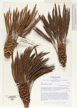
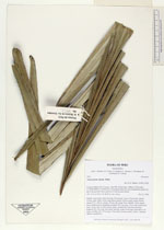
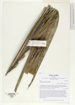
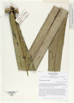
| Identification | Astrocaryum chonta Mart. |
| Determined by | H. Balslev |
| Identification qualifier | |
| Field notes | Solitary, large palm. Stem 5m long, 25cm thick. Leaves 12 per stem; sheath 110cm, open; spines 10cm long, black; petiole 150cm, green; rachis 430cm; lamina 475 x 280cm; pinnae 102 per side, basal 70cm, middle 125cm, apical 60cm. Inflorescence interfoliar; prophyll 25(+)cm long, 12cm wide; peduncular bract 110cm long, woody, brown, spiny, inserted 40(+)cm from the base; peduncle 90(+)cm long, 4cm thick, smooth; rachis 47cm long, branched to 1st order; rachillae 350, 17cm long, 0.5cm thick; flowers sessile, yellow. Transect HB356-outsideSU01. |
_HB7852_Astrocaryum_chonta.jpg)
_HB7852_Astrocaryum_chonta.jpg)
_HB7852_Astrocaryum_chonta.jpg)
_HB7852_Astrocaryum_chonta.jpg)
_HB7852_Astrocaryum_chonta.jpg)
_HB7852_Astrocaryum_chonta.jpg)
_HB7852_Astrocaryum_chonta.jpg)
_HB7852_Astrocaryum_chonta.jpg)
| |
 Other records of Astrocaryum chonta Other records of Astrocaryum chontaThe map displays only records from the Aarhus Herbarium Database. The records may not represent the full distribution of Astrocaryum chonta |
| New Search Modify Search |