| Collector | Balslev, H. |
| Number | 7847 |
| Collected with | C. Grandez, G. Criollo, D. Pedersen, L. Stewart, I. Nicolajsen, W. Eiserhardt, D. Lindvig |
| Country | Peru |
| Subpart | Ucayali-Atalaya |
| County | |
| Locality | Rio Ucayali, S of outlet of Río Schahuaya, entrance to Fernando Stahl, 170km S of Pucallpa (UTM 8907515 S; 593540 W). Flood plain rainforest w innudation marks up to 3 m above the ground. |
| Coordinates | 9° 52' 55.2'' S 74° 8' 48.6'' W |
| Minimum elevation (m) | 161 |
| Maximum elevation (m) | 0 |
| Start date | 2008/10/21 |
| End date | 0/00/00 |
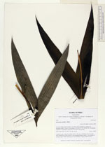
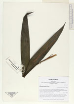
| Family | Arecaceae |
| Identification | Geonoma laxiflora Mart. |
| Determined by | H. Balslev |
| Identification qualifier | |
| Field notes | Cespitose, erect, understory palm. Stem 1.5m long, 1cm thick. Leaves 10 per stem; sheath 8cm, open; petiole 12cm, margined, green; rachis 11cm; lamina 35 x 26cm, entire, bifid. Inflorescence bud infrafoliar. Transect HB355-SU21. |
_HB7847_Geonoma_laxiflora.jpg)
_HB7847_Geonoma_laxiflora.jpg)
_HB7847_Geonoma_laxiflora.jpg)
|
 Other records of Geonoma laxiflora