| Collector | Balslev, H. |
| Number | 7843 |
| Collected with | C. Grandez, G. Criollo, D. Pedersen, L. Stewart, I. Nicolajsen, W. Eiserhardt, D. Lindvig |
| Country | Peru |
| Subpart | Ucayali-Atalaya |
| County | |
| Locality | Rio Ucayali, N of outlet of Río Schahuaya (168 km S of Pucallpa), entrance to Fernando Stahl (UTM 8909853 S; 593348 W). Flood plain rainforest, mosaic of patches with tall trees and low liana tangles. |
| Coordinates | 9° 51' 39.1'' S 74° 8' 55.1'' W |
| Minimum elevation (m) | 182 |
| Maximum elevation (m) | 0 |
| Start date | 2008/10/21 |
| End date | 0/00/00 |
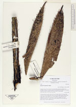
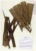
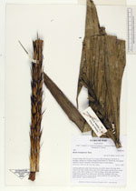
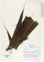
| Family | Arecaceae |
| Identification | Bactris brongniartii Mart. |
| Determined by | H. Balslev |
| Identification qualifier | |
| Field notes | Colonial understory palm. Stem 4m long, 5cm thick; spines 5cm long, black. Leaves 8 per stem; sheath 44cm, open, with yellow spines; petiole 62cm, round, green; rachis 180cm; lamina 215 x 100cm; pinnae 24 per side, basal 55cm, middle 85cm, apical 35cm. Infloresence interfoliar; prophyll 23cm long; peduncular bract 60cm, woody, brown, spiny; peduncle 20(+)cm long, 2cm thick, smooth. Transect HB354-SU37. |
_HB7843_Bactris_brongniartii.jpg)
_HB7843_Bactris_brongniartii.jpg)
_HB7843_Bactris_brongniartii.jpg)
_HB7843_Bactris_brongniartii.jpg)
|