| Collector | Balslev, H. |
| Number | 7838 |
| Collected with | C. Grandez, G. Criollo, D. Pedersen, L. Stewart, I. Nicolajsen, W. Eiserhardt, D. Lindvig |
| Country | Peru |
| Subpart | Ucayali-Atalaya |
| County | |
| Locality | About 180 km S of Pucallpa, 17 km to the east along a timber-road from Nueva Italia, which on a Río Ucayali oxbow (UTM 8918867 S; 630424 W). Tall rainforest on flat terrace; Mauritia flexuosa swamp seen but not entered for collections. |
| Coordinates | 9° 46' 42'' S 73° 48' 39'' W |
| Minimum elevation (m) | 240 |
| Maximum elevation (m) | 0 |
| Start date | 2008/10/19 |
| End date | 0/00/00 |
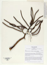
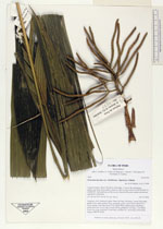
| Family | Arecaceae |
| Identification | Geonoma maxima var. chelidonura (Spruce)A.J.Hend. |
| Determined by | H. Balslev |
| Identification qualifier | |
| Field notes | Cespitose, erect, understory palm. Stem 5m long, 2cm thick. Leaves 9 per stem; sheath 22cm, open; petiole 52cm, margined, green; rachis 40cm; lamina 82 x 83cm; pinnae 2 per side, basal 57cm, apical 58cm. Inflorescence interfoliar; peduncular bract 12cm long, woody, brown; peduncle 7cm long, 1.3cm thick; rachis 9cm long, branched to 2nd order; rachillae 20, 10cm long, 0.6cm thick. Transect HB353-SU83. |
_HB7838_Geonoma_maxima_chelidonura.jpg)
_HB7838_Geonoma_maxima_chelidonura.jpg)
_HB7838_Geonoma_maxima_chelidonura.jpg)
_HB7838_Geonoma_maxima_chelidonura.jpg)
|