| Collector | Balslev, H. |
| Number | 7834 |
| Collected with | C. Grandez, G. Criollo, D. Pedersen, L. Stewart, I. Nicolajsen, W. Eiserhardt, D. Lindvig |
| Country | Peru |
| Subpart | Ucayali-Atalaya |
| County | |
| Locality | About 180 km S of Pucallpa, 26 km to the east along a timber road from Nueva Italia, which on a Río Ucayali oxbow (UTM 8919364 S; 633893 W). Tall rainforest on hills of red clay with small creeks sometimes surrounded tiny alluvial terraces. |
| Coordinates | 9° 46' 25.4'' S 73° 46' 45.2'' W |
| Minimum elevation (m) | 236 |
| Maximum elevation (m) | 0 |
| Start date | 2008/10/19 |
| End date | 0/00/00 |
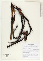
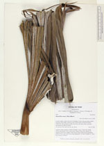
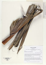
| Family | Arecaceae |
| Identification | Mauritiella armata (Mart.)Burret |
| Determined by | H. Balslev |
| Identification qualifier | |
| Field notes | Cespitose clump of palms of different heights. Leaves 10 per stem; sheath 120cm, open; petiole 25cm round, green; lamina 250cm wide, palmate; 82 segments, basal 90cm, middle 125cm, apical 120cm. Inflorescence interfoliar; peduncle 35cm long; rachis 50cm long, branched to 1st order; rachillae 13, 35cm long. Outside of transect. |
_HB7834_Mauritiella_armata.jpg)
_HB7834_Mauritiella_armata.jpg)
_HB7834_Mauritiella_armata.jpg)
_HB7834_Mauritiella_armata.jpg)
_HB7834_Mauritiella_armata.jpg)
_HB7834_Mauritiella_armata.jpg)
|
 Other records of Mauritiella armata