| Collector | Balslev, H. |
| Number | 7833 |
| Collected with | C. Grandez, G. Criollo, D. Pedersen, L. Stewart, I. Nicolajsen, W. Eiserhardt, D. Lindvig |
| Country | Peru |
| Subpart | Ucayali-Atalaya |
| County | |
| Locality | About 180 km S of Pucallpa, 26 km to the east along a timber road from Nueva Italia, which on a Río Ucayali oxbow (UTM 8925147 S; 637716 W). Tall rainforest on hills of red clay with small creeks sometimes surrounded tiny alluvial terraces. |
| Coordinates | 9° 43' 16.7'' S 73° 44' 40.4'' W |
| Minimum elevation (m) | 228 |
| Maximum elevation (m) | 0 |
| Start date | 2008/10/19 |
| End date | 0/00/00 |
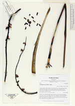
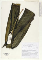
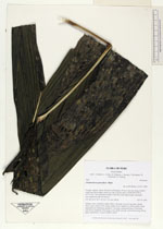
| Family | Arecaceae |
| Identification | Chamaedorea pauciflora Mart. |
| Determined by | H. Balslev |
| Identification qualifier | |
| Field notes | Solitary, erect, understory palm. Stem 1.5m long. Leaves 9 per stem; sheath 32cm, open; petiole 27cm, green; rachis 52cm; lamina 82 x 60cm, entire, bifid. Infructescence interfoliar; prophyll 11cm long; peduncular bract 13cm long, soft, brown; peduncle 50cm long, 0.7cm thick, smooth; rachis 46cm long, 0.8cm thick, unbranched. Transect HB352-SU56. |
_HB7833_Chamaedorea_pauciflora.jpg)
_HB7833_Chamaedorea_pauciflora.jpg)
_HB7833_Chamaedorea_pauciflora.jpg)
|