AAU Herbarium Database |
| New Search Modify Search |
| Collector | Balslev, H. |
| Number | 7827 |
| Collected with | C. Grandez, G. Criollo, D. Pedersen, L. Stewart, I. Nicolajsen, W. Eiserhardt, D. Lindvig |
| Country | Peru |
| Subpart | Ucayali-Atalaya |
| County | |
| Locality | About 180 km S of Pucallpa, 26 km to the east along a timber road from Nueva Italia, which on a Río Ucayali oxbow (UTM 8925210 S; 637476 W). Tall rainforest on hills of red clay with small creeks sometimes surrounded tiny alluvial terraces. |
| Coordinates | 9° 43' 14.6'' S 73° 44' 48.3'' W |
| Minimum elevation (m) | 222 |
| Maximum elevation (m) | 0 |
| Start date | 2008/10/19 |
| End date | 0/00/00 |
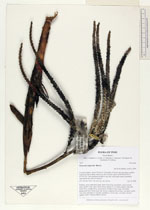
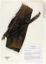
| Family | Arecaceae |
| Identification | Geonoma triglochin Burret |
| Determined by | H. Balslev |
| Identification qualifier | |
| Field notes | Solitary, erect, understory palm. Stem 4.5m long, 4cm thick. Leaves 20 per stem; sheath 27cm, open; rachis 90cm; lamina 112 x 40cm; pinnae 4 per side, basal 50cm, middle 45cm, apical 45cm. Prophyll 19cm long, 3cm thick; peduncular bract 30cm long, soft, brown; peduncle 41cm long, 1cm thick; rachis 7cm long, branched to 1st order; rachillae 6, 30cm long, 1cm thick; flowers sunken, white. Transect HB352-SU04. |
_HB7827_Geonoma_triglochin.jpg)
_HB7827_Geonoma_triglochin.jpg)
_HB7827_Geonoma_triglochin.jpg)
_HB7827_Geonoma_triglochin.jpg)
| |
 Other records of Geonoma triglochin Other records of Geonoma triglochinThe map displays only records from the Aarhus Herbarium Database. The records may not represent the full distribution of Geonoma triglochin |
| New Search Modify Search |