| Collector | Balslev, H. |
| Number | 7825 |
| Collected with | C. Grandez, G. Criollo, D. Pedersen, L. Stewart, I. Nicolajsen, W. Eiserhardt, D. Lindvig |
| Country | Peru |
| Subpart | Ucayali-Atalaya |
| County | |
| Locality | About 180 km S of Pucallpa, 10 km to the east along a timber-road from Nueva Italia, which on a Río Ucayali oxbow (UTM 8915274 S; 623918 W). Tall rainforest on flat terrace, dominated by Lepidocaryum tenue. |
| Coordinates | 9° 48' 39.7'' S 73° 52' 12.1'' W |
| Minimum elevation (m) | 207 |
| Maximum elevation (m) | 0 |
| Start date | 2008/10/18 |
| End date | 0/00/00 |
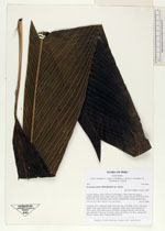
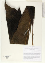
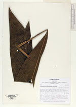
| Family | Arecaceae |
| Identification | Geonoma stricta var. stricta (Poit.)Kunth |
| Determined by | H. Balslev |
| Identification qualifier | |
| Field notes | Cespitose, erect, understory palm. Stem 2m long, 2cm thick. Leaves 7 per stem; sheath 10cm, open; petiole 10cm, margined, green; rachis 58cm; lamina 69 x 23cm, entire, bifid. Inflorescence infrafoliar; prophyll inserted 2cm from the base; peduncle 5cm long, 1cm thick; rachis 16cm long, 2cm thick, unbranched. Flowers sunken, white. Transect HB351-SU89. |
_HB7825_Geonoma_stricta_stricta.jpg)
_HB7825_Geonoma_stricta_stricta.jpg)
_HB7825_Geonoma_stricta_stricta.jpg)
|