AAU Herbarium Database |
| New Search Modify Search |
| Collector | Balslev, H. |
| Number | 7824 |
| Collected with | C. Grandez, G. Criollo, D. Pedersen, L. Stewart, I. Nicolajsen, W. Eiserhardt, D. Lindvig |
| Country | Peru |
| Subpart | Ucayali-Atalaya |
| County | |
| Locality | About 180 km S of Pucallpa, 10 km to the east along a timber-road from Nueva Italia, which on a Río Ucayali oxbow (UTM 8915233 S; 623946 W). Tall rainforest on flat terrace, dominated by Lepidocaryum tenue. |
| Coordinates | 9° 48' 41'' S 73° 52' 11.2'' W |
| Minimum elevation (m) | 198 |
| Maximum elevation (m) | 0 |
| Start date | 2008/10/18 |
| End date | 0/00/00 |
| Family | Arecaceae |
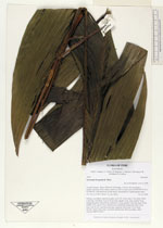
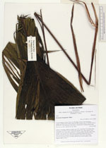
| Identification | Geonoma brongniartii Mart. |
| Determined by | H. Balslev |
| Identification qualifier | |
| Field notes | Solitary, ascending, understory palm; roots 100, 10cm long, 0.2cm thick. Stem 0.5m long, 4cm thick. Leaves 10 per stem; sheath 15cm, open; petiole 74cm, margined, green; rachis 66cm; lamina 81 x 46cm; pinnae 3 per side, basal 33cm, middle 37cm, apical 35cm. Inflorescence interfoliar; peduncular bract 26cm long, soft, brown, inserted at the base; peduncle 36cm long, 0.5cm thick, smooth; rachis 30cm long, 1cm thick, unbranched; flowers sunken, white. Transect HB351-SU81. |
_HB7824_Geonoma_brongniartii.jpg)
_HB7824_Geonoma_brongniartii.jpg)
| |
| Display all 110 georeferenced records of Geonoma Geonoma brongniartii |
| New Search Modify Search |