| Collector | Balslev, H. |
| Number | 7810 |
| Collected with | C. Grandez, G. Criollo, D. Pedersen, L. Stewart, I. Nicolajsen, W. Eiserhardt, D. Lindvig |
| Country | Peru |
| Subpart | Ucayali-Atalaya |
| County | |
| Locality | About 180 km S of Pucallpa, 15.5 km to the east along a timber-road from Nueva Italia, which on a Río Ucayali oxbow (UTM 8917914 S; 629448 W). Tall rainforest on flat terrace, dominated by Lepidocaryum tenue. |
| Coordinates | 9° 47' 13.1'' S 73° 49' 10.9'' W |
| Minimum elevation (m) | 191 |
| Maximum elevation (m) | 0 |
| Start date | 2008/10/18 |
| End date | 0/00/00 |
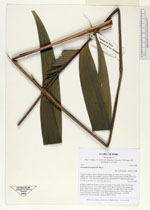
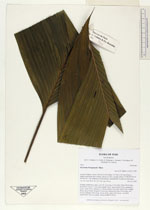
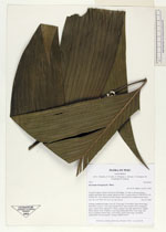
| Family | Arecaceae |
| Identification | Geonoma brongniartii Mart. |
| Determined by | H. Balslev |
| Identification qualifier | |
| Field notes | Solitaryr understory palm; roots 50, 5cm long, 0.2cm thick. Stem 60cm long, 4cm thick. Leaves 11 per stem; sheath 23cm, open; petiole 65cm, margined, green; rachis 70cm; lamina 97 x 66cm; pinnae 4 per side, basal 30cm, middle 46cm, apical 42cm. Prophyll 31cm long; peduncular bract 31cm long, soft, brown; peduncle 49cm long, 0.6cm thick; rachis 29cm long, 1cm thick, unbranched; flowers sunken. Transect HB350-SU21. |
_HB7810_Geonoma_brongniartii.jpg)
_HB7810_Geonoma_brongniartii.jpg)
_HB7810_Geonoma_brongniartii.jpg)
|