AAU Herbarium Database |
| New Search Modify Search |
| Collector | Balslev, H. |
| Number | 7807 |
| Collected with | C. Grandez, G. Criollo, D. Pedersen, L. Stewart, I. Nicolajsen, W. Eiserhardt, D. Lindvig |
| Country | Peru |
| Subpart | Ucayali-Atalaya |
| County | |
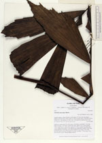
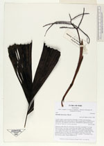
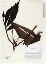
| Locality | About 180 km S of Pucallpa, 15.5 km to the east along a timber-road from Nueva Italia, which on a Río Ucayali oxbow (UTM 8917933 S; 629455 W). Tall rainforest on flat terrace, dominated by Lepidocaryum tenue. |
| Coordinates | 9° 47' 12.5'' S 73° 49' 10.7'' W |
| Minimum elevation (m) | 221 |
| Maximum elevation (m) | 0 |
| Start date | 2008/10/18 |
| End date | 0/00/00 |
| Family | Arecaceae |
| Identification | Iriartella stenocarpa Burret |
| Determined by | H. Balslev |
| Identification qualifier | |
| Field notes | Understory palm. Roots 50, 20cm long, 0.5cm thick; crownshaft 17 cm long. Stem 2m long, 1.5cm thick. Leaves 6 per stem; sheath 17cm, closed; petiole 15cm, round, brown; rachis 45cm; lamina 50 x 40cm; pinnae 6 per side, basal 14cm, middle 25cm, apical 11cm. Inflorescence interfoliar; prophyll 18cm long; peduncular bract 23cm long, soft, green; peduncle 25cm long, 0.5cm wide, smooth; rachis 4cm long, branched to 1st order; rachillae 7, 13cm long, 0.3cm thick; flowers sessile. Transect HB350-SU18. |
_HB7807_Iriartella_stenocarpa.jpg)
_HB7807_Iriartella_stenocarpa.jpg)
_HB7807_Iriartella_stenocarpa.jpg)
| |
| Display all 32 georeferenced records of Iriartella Iriartella stenocarpa |
| New Search Modify Search |