| Collector | Balslev, H. |
| Number | 7806 |
| Collected with | C. Grandez, G. Criollo, D. Pedersen, L. Stewart, I. Nicolajsen, W. Eiserhardt, D. Lindvig |
| Country | Peru |
| Subpart | Ucayali-Atalaya |
| County | |
| Locality | About 180 km S of Pucallpa, 15.5 km to the east along a timber-road from Nueva Italia, which on a Río Ucayali oxbow (UTM 8917931 S; 629449 W). Tall rainforest on flat terrace, dominated by Lepidocaryum tenue. |
| Coordinates | 9° 47' 12.5'' S 73° 49' 10.9'' W |
| Minimum elevation (m) | 239 |
| Maximum elevation (m) | 0 |
| Start date | 2008/10/18 |
| End date | 0/00/00 |
| Family | Arecaceae |
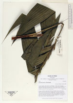
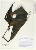
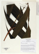
| Identification | Geonoma deversa (Poit.)Kunth |
| Determined by | H. Balslev |
| Identification qualifier | |
| Field notes | Cespitose understory palm. Stem 3m long, 2cm thick. Leaves 10 per stem; sheath 12cm, open; petiole 26cm, margined, green; rachis 43cm; lamina 64 x 34cm; pinnae 8 per side, basal32cm, middle 38cm, apical24cm. Infloresence infrafoliar; peduncular bract inserted 1cm from base; peduncle 11cm long, 1cm thick; rachis 10cm long, branched to 2nd order; rachillae 12, 17cm long, 0.2 thick; flowers sunken. Transect HB350-SU17. |
_HB7806_Geonoma_deversa.jpg)
_HB7806_Geonoma_deversa.jpg)
_HB7806_Geonoma_deversa.jpg)
|