| Collector | Balslev, H. |
| Number | 7794 |
| Collected with | C. Grandez, G. Criollo, D. Pedersen, L. Stewart, I. Nicolajsen, W. Eiserhardt, D. Lindvig |
| Country | Peru |
| Subpart | Ucayali-Atalaya |
| County | |
| Locality | About 180 km S of Pucallpa, 4.5 km to the east along timber-road from Nueva Italia which on a Río Ucayali oxbow (UTM 8912184 S; 618814 W). Tall rainforest on flat terrace, dominated by Lepidocaryum tenue - lightly dturbed. |
| Coordinates | 9° 50' 20.8'' S 73° 54' 59.3'' W |
| Minimum elevation (m) | 195 |
| Maximum elevation (m) | 0 |
| Start date | 2008/10/17 |
| End date | 0/00/00 |
| Family | Arecaceae |
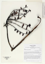
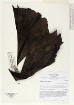
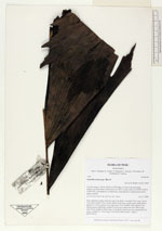
| Identification | Iriartella stenocarpa Burret |
| Determined by | H. Balslev |
| Identification qualifier | |
| Field notes | Erect understory palm. Stem 4m long, 2cm thick; crownhaft 32cm long. Leaves 5 per stem; sheath 32cm, closed; petiole 26cm long, round, green; rachis 80cm; lamina 93 x 56cm; pinnae 8 per side, basal 14cm, middle 35cm, apical 19cm. Infructescence infrafoliar; prophyll 30cm long; peduncular bract 38cm long, soft, brown; peduncle 48cm long, 0.7cm thick; rachis 6cm long, branched to 1st order; rachillae 10, 18cm long, 0.2cm thick; fruits sessile. Transect HB349-SU61. |
_HB7794_Iriartella_stenocarpa.jpg)
_HB7794_Iriartella_stenocarpa.jpg)
_HB7794_Iriartella_stenocarpa.jpg)
|