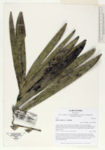
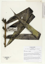
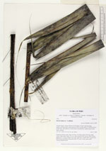
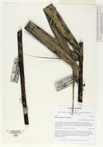
| Collector | Balslev, H. |
| Number | 7793 |
| Collected with | C. Grandez, G. Criollo, D. Pedersen, L. Stewart, I. Nicolajsen, W. Eiserhardt, D. Lindvig |
| Country | Peru |
| Subpart | Ucayali-Atalaya |
| County | |
| Locality | About 180 km S of Pucallpa, 4.5 km to the east along timber-road from Nueva Italia which on a Río Ucayali oxbow (UTM 8912258 S; 618791 W). Tall rainforest on flat terrace, dominated by Lepidocaryum tenue - lightly dturbed. |
| Coordinates | 9° 50' 18.4'' S 73° 55' .1'' W |
| Minimum elevation (m) | 205 |
| Maximum elevation (m) | 0 |
| Start date | 2008/10/17 |
| End date | 0/00/00 |
| Family | Arecaceae |
| Identification | Bactris halmoorei A.J.Hend. |
| Determined by | H. Balslev |
| Identification qualifier | |
| Field notes | Cespitose midstory palm. Stem 7m long, 7cm thick; spines 5cm long, black. Leaves 10per stem; sheath 37(+)cm, open; petiole 69cm, brown; rachis 200cm; lamina 220 x 102cm; pinnae 39 per side, basal 20cm, middle 58cm, apical 20cm. Infloresence interfoliar; peduncular bract 39(+)cm, woody, green, spiny. Transect HB349-SU44. |
_HB7793_Bactris_halmoorei.jpg)
_HB7793_Bactris_halmoorei.jpg)
_HB7793_Bactris_halmoorei.jpg)
|
 Other records of Bactris halmoorei