AAU Herbarium Database |
| New Search Modify Search |
| Collector | Balslev, H. |
| Number | 7786 |
| Collected with | C. Grandez, G. Criollo, D. Pedersen, L. Stewart, I. Nicolajsen, W. Eiserhardt, D. Lindvig |
| Country | Peru |
| Subpart | Ucayali-Atalaya |
| County | |
| Locality | About 0.5 km from Río Ucayali on eastern bank 7km SW of Bolognes (UTM 8887065 S; 604557 W)i. Logged floodplain forest with patches of tall trees in a matrix of low dense tangles of lianas. |
| Coordinates | 10° 4' 0'' S 74° 2' 45'' W |
| Minimum elevation (m) | 180 |
| Maximum elevation (m) | 0 |
| Start date | 2008/10/16 |
| End date | 0/00/00 |
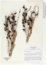
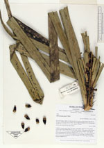
| Family | Arecaceae |
| Identification | Astrocaryum jauari Mart. |
| Determined by | H. Balslev |
| Identification qualifier | |
| Field notes | Cespitose canopy palm. Stem 12m long, 14cm thick; spines 6cm long, black. Leaves 8 per stem; sheath 180cm long, open; petiole 10cm, green; rachis 340cm; lamina 375 x 234cm; pinnae 147 per side, basal 86cm, middle 113cm, apical 34cm. Infructescence interfoliar; prophyll 66(+)cm long, 12cm wide; peduncular bract inserted 85(+)cm from base; peduncle 100(+)cm long, 7cm thick, spiny; rachis 91cm long, branched to 1st order; rachillae 100, 39cm long, 0.3cm thick. Transect HB348-SU74. |
_HB7786_Astrocaryum_jauari.jpg)
_HB7786_Astrocaryum_jauari.jpg)
_HB7786_Astrocaryum_jauari.jpg)
_HB7786_Astrocaryum_jauari.jpg)
| |
 Other records of Astrocaryum jauari Other records of Astrocaryum jauariThe map displays only records from the Aarhus Herbarium Database. The records may not represent the full distribution of Astrocaryum jauari |
| New Search Modify Search |