| Collector | Balslev, H. |
| Number | 7770 |
| Collected with | C. Grandez, G. Criollo, D. Pedersen, L. Stewart, I. Nicolajsen, W. Eiserhardt, D. Lindvig |
| Country | Peru |
| Subpart | Ucayali-Atalaya |
| County | |
| Locality | About 200 km S of Pucallpa, 0.5 km of Río Ucayali, 9km S of Bolognesi (UTM 8883970 S; 612590 W). Tall floodplain rainforest, apparently on old leves separated by depressions. |
| Coordinates | 10° 5' 39.9'' S 73° 58' 20.8'' W |
| Minimum elevation (m) | 186 |
| Maximum elevation (m) | 0 |
| Start date | 2008/10/16 |
| End date | 0/00/00 |
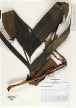
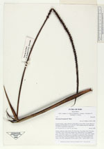
| Family | Arecaceae |
| Identification | Geonoma brongniartii Mart. |
| Determined by | H. Balslev |
| Identification qualifier | |
| Field notes | Solitary understory palm. Roots 100; 25cm long, 0.2cm thick. Stem 0.5m long, 4cm thick. Leaves 14 per stem; sheath 20cm, open; petiole 57cm, margined, green; rachis 84cm; lamina 109 x 64cm; pinnae 14 per side, basal 26cm, middle 37cm, apical 30cm. Inflorescence interfoliar; prophyll 26cm long; peduncular bract 33cm long, soft, brown; peduncle 50cm long, 0.5cm thick; rachis 27cm long, 0.6cm thick, unbranched; flowers sunken, white. Transect HB347-SU06. |
_HB7770_Geonoma_brongniartii.jpg)
_HB7770_Geonoma_brongniartii.jpg)
_HB7770_Geonoma_brongniartii.jpg)
_HB7770_Geonoma_brongniartii.jpg)
|