| Collector | Balslev, H. |
| Number | 7754 |
| Collected with | C. Grandez, G. Criollo, D. Pedersen, L. Stewart, I. Nicolajsen, W. Eiserhardt, D. Lindvig |
| Country | Peru |
| Subpart | Ucayali-Atalaya |
| County | |
| Locality | Río Ucayali, eastern bank, 33km NW of Atalaya (UTM 8828425 S; 621648 W). Apparently unflooded tall rainforest on a piece of flat land entered from an escarpment along the river. |
| Coordinates | 10° 35' 47.2'' S 73° 53' 16.8'' W |
| Minimum elevation (m) | 230 |
| Maximum elevation (m) | 0 |
| Start date | 2008/10/14 |
| End date | 0/00/00 |
| Family | Arecaceae |
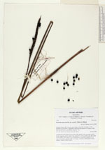
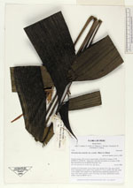
| Identification | Geonoma macrostachys var. acaulis (Mart.)A.J.Hend. |
| Determined by | H. Balslev |
| Identification qualifier | |
| Field notes | Acaulescent rosette-palm. Leaves 8 per stem; sheath 20cm long, open; petiole 62cm, margined, green; rachis 41cm; lamina 60 x 52cm; pinnae 3 per side, basal 33cm, middle 35cm, apical 33cm. Infructescence interfoliar; peduncle 87cm long, 0.4cm thick, smooth; rachis 13cm long, 1cm thick, unbranched; flowers sunken. Transect HB346-way in. |
_HB7754_Geonoma_macrostachys_acaulis.jpg)
_HB7754_Geonoma_macrostachys_acaulis.jpg)
_HB7754_Geonoma_macrostachys_acaulis.jpg)
|