| Collector | Balslev, H. |
| Number | 7751 |
| Collected with | C. Grandez, G. Criollo, D. Pedersen, L. Stewart, I. Nicolajsen, W. Eiserhardt, D. Lindvig |
| Country | Peru |
| Subpart | Ucayali-Atalaya |
| County | |
| Locality | Río Ucayali, west bank, 18km N of Atalaya (UTM 8823976 S; 621282 W). Floodplain forest on very level terrain with many Attalea phalerata and areas of dense, low liana forest. |
| Coordinates | 10° 38' 12'' S 73° 53' 28.3'' W |
| Minimum elevation (m) | 212 |
| Maximum elevation (m) | 0 |
| Start date | 2008/10/14 |
| End date | 0/00/00 |
| Family | Arecaceae |
| Identification | Bactris chaveziae A.J.Hend. |
| Determined by | H. Balslev |
| Identification qualifier | |
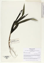
| Field notes | Seedling. Leaves 3 per stem; sheath 5cm, closed; petiole 9cm, margined, green; rachis 4cm; lamina 14 x 8cm, entire, bifid. Transect HB345-SU41. |
_HB7751_Bactris_chaveziae.jpg)
|
 Other records of Bactris chaveziae