| Collector | Balslev, H. |
| Number | 7749 |
| Collected with | C. Grandez, G. Criollo, D. Pedersen, L. Stewart, I. Nicolajsen, W. Eiserhardt, D. Lindvig |
| Country | Peru |
| Subpart | Ucayali-Atalaya |
| County | |
| Locality | Río Ucayali, west bank, 18km N of Atalaya (UTM 8823971 S; 621443 W). Floodplain forest on very level terrain with many Attalea phalerata and areas of dense, low liana forest. |
| Coordinates | 10° 38' 12.2'' S 73° 53' 23'' W |
| Minimum elevation (m) | 225 |
| Maximum elevation (m) | 0 |
| Start date | 2008/10/14 |
| End date | 0/00/00 |
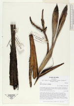
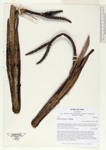
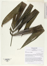
| Family | Arecaceae |
| Identification | Bactris chaveziae A.J.Hend. |
| Determined by | H. Balslev |
| Identification qualifier | |
| Field notes | Cespitose palm. Stem 0.9m long, 4cm thick; spines 6cm long, light brown. Leaves 7 per stem; sheath 50cm, open; petiole 105cm, round, brown; rachis 196cm; lamina 229 x 120cm; pinnae 23 per side, basal 65cm, middle 48cm, apical 38cm. Inflorescence infrafoliar; prophyll 30cm long, 2.5cm wide; peduncular bract 49cm long, woody with spines, brown; peduncle 40cm long, 1.5cm thick; rachis 0cm, branched to 1st order; rachillae 2, 9cm long, 1cm thick; flowers sessile. Transect HB345-SU09. |
_HB7749_Bactris_chaveziae.jpg)
_HB7749_Bactris_chaveziae.jpg)
_HB7749_Bactris_chaveziae.jpg)
|
 Other records of Bactris chaveziae