AAU Herbarium Database |
| New Search Modify Search |
| Collector | Balslev, H. |
| Number | 7734 |
| Collected with | C. Grandez, G. Criollo, D. Pedersen, L. Stewart, I. Nicolajsen, W. Eiserhardt, D. Lindvig |
| Country | Peru |
| Subpart | Junín |
| County | |
| Locality | Hills some 4km WSW of Atalaya along road departing from end of airport runway (UTM 8813162 S; 632440 W). Flat microfloodplain among hills in tall rainforest with small streams and sometimes wet soils. |
| Coordinates | 10° 44' 2.7'' S 73° 47' 19.8'' W |
| Minimum elevation (m) | 320 |
| Maximum elevation (m) | 0 |
| Start date | 2008/10/13 |
| End date | 0/00/00 |
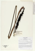
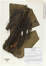
| Family | Arecaceae |
| Identification | Geonoma macrostachys var. macrostachys Mart. |
| Determined by | H. Balslev |
| Identification qualifier | |
| Field notes | Acaulescent, rosette-palm. Leaves 7 per stem; sheath 20cm long, open; petiole 50cm, margined, green; rachis 70cm; lamina 97 x 36cm; pinnae 3 per side, basal 28cm, middle 25cm, apical 30cm. Infructescence interfoliar; prophyll 9cm long; peduncular bract 30cm long, brown, inserted at the base; peduncle 90cm long, 0.5cm thick, smooth; rachis 22cm long, 1cm thick, unbranched; flowers sunken. Transect HB344-SU21. |
_HB7734_Geonoma_macrostachys_macrostachys.jpg)
_HB7734_Geonoma_macrostachys_macrostachys.jpg)
_HB7734_Geonoma_macrostachys_macrostachys.jpg)
_HB7734_Geonoma_macrostachys_macrostachys.jpg)
_HB7734_Geonoma_macrostachys_macrostachys.jpg)
| |
| Display all 220 georeferenced records of Geonoma Geonoma macrostachys var. macrostachys |
| New Search Modify Search |