AAU Herbarium Database |
| New Search Modify Search |
| Collector | Balslev, H. |
| Number | 7719 |
| Collected with | C. Grandez, G. Criollo, D. Pedersen, L. Stewart, I. Nicolajsen, W. Eiserhardt, D. Lindvig |
| Country | Peru |
| Subpart | Junín |
| County | |
| Locality | Hills some 6km WSW of Atalaya along road departing from end of airport runway (UTM 8810740 S; 631270 W). Tall rainforest on steep hills. |
| Coordinates | 10° 45' 21.7'' S 73° 47' 58'' W |
| Minimum elevation (m) | 563 |
| Maximum elevation (m) | 0 |
| Start date | 2008/10/13 |
| End date | 0/00/00 |
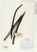
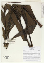
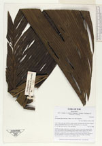
| Family | Arecaceae |
| Identification | Geonoma macrostachys var. macrostachys Mart. |
| Determined by | H. Balslev |
| Identification qualifier | |
| Field notes | Acaulescent, giant, understory-rosette palm. Leaves 13 per stem; sheath 35cm long, open; petiole 32cm, margined, green; rachis 104cm; lamina 138 x 58cm; pinnae 8 per side, basal 38cm, middle 40cm, apical 40cm. Infructescence interfoliar; prophyll 35cm long; peduncular bract 54cm long, brown, inserted at the base; peduncle 135cm long, 0.6cm thick; rachis 31cm long, 1cm thick, unbranched; flowers sunken. Transect HB343-SU14. |
_HB7719_Geonoma_macrostachys_macrostachys.jpg)
_HB7719_Geonoma_macrostachys_macrostachys.jpg)
| |
| Display all 220 georeferenced records of Geonoma Geonoma macrostachys var. macrostachys |
| New Search Modify Search |