AAU Herbarium Database |
| New Search Modify Search |
| Collector | Balslev, H. |
| Number | 7695 |
| Collected with | C. Grandez, G. Criollo, D. Pedersen, L. Stewart, I. Nicolajsen, W. Eiserhardt, D. Lindvig |
| Country | Peru |
| Subpart | Junín |
| County | |
| Locality | Just N of the road along Río Tambo 5km S of Atalaya (UTM 8809782 S; 634509 W). Tall rainforest on long, not steep slope. |
| Coordinates | 10° 45' 52.5'' S 73° 46' 11.2'' W |
| Minimum elevation (m) | 440 |
| Maximum elevation (m) | 0 |
| Start date | 2008/10/11 |
| End date | 0/00/00 |
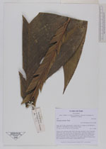
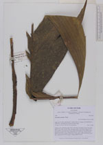
| Family | Arecaceae |
| Identification | Geonoma camana Trail |
| Determined by | H. Balslev |
| Identification qualifier | |
| Field notes | Solitary, erect, understory palm. Stem 0.6m long, 5cm thick. Leaves 5 per stem; sheath 20cm, open; petiole 58cm, margined, green; rachis 85cm; lamina 110 x 44cm; pinnae 3 per side, basal 29cm, middle 30cm, apical 30cm. Inflorescence interfoliar; prophyll 18cm long; peduncular bract 25cm long, woody, brown, inserted at the base; peduncle 56cm long, 0.4cm thick; rachis 17cm long, 0.8cm thick, unbranched; flowers sunken. Transect HB341-SU14. |
_HB7695_Geonoma_camana.jpg)
_HB7695_Geonoma_camana.jpg)
| |
| Display all 57 georeferenced records of Geonoma Geonoma camana |
| New Search Modify Search |