| Collector | Balslev, H. |
| Number | 7694 |
| Collected with | C. Grandez, G. Criollo, D. Pedersen, L. Stewart, I. Nicolajsen, W. Eiserhardt, D. Lindvig |
| Country | Peru |
| Subpart | Junín |
| County | |
| Locality | Just N of the road along Río Tambo 5km S of Atalaya (UTM 8809822 S; 634532 W). Tall rainforest on long, not steep slope. |
| Coordinates | 10° 45' 51.2'' S 73° 46' 10.5'' W |
| Minimum elevation (m) | 399 |
| Maximum elevation (m) | 0 |
| Start date | 2008/10/11 |
| End date | 0/00/00 |
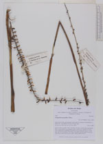
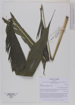
| Family | Arecaceae |
| Identification | Chamaedorea pauciflora Mart. |
| Determined by | H. Balslev |
| Identification qualifier | |
| Field notes | Solitary understory palm. Stem 0.4m long, 2cm thick. Leaves 8 per stem; sheath 23cm, closed; petiole 23cm margined, green; rachis 63cm; lamina 93 x 35cm, entire. Inflorescence interfoliar; prophyll 5cm long; peduncular bracts 3, 20cm long, soft, brown; peduncle 57cm long, 0.5cm thick, smooth; rachis 37cm long, 0.5cm thick, unbranched; flowers sessile. Transect HB341-SU10. |
_HB7694_Chamaedorea_pauciflora.jpg)
_HB7694_Chamaedorea_pauciflora.jpg)
_HB7694_Chamaedorea_pauciflora.jpg)
|